

Presidential Traverse - Nov 17, 2006
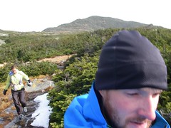
tues nov 14th i returned to the shire to spend time with my family for thanksgiving. my arrangement with myself was that i would go home and do some sort of long fun run/hike/skin/snowshoe.. something.  so i decided i hadto do the presidential traverse. it's a 25.5 mile trek with 9,600+ feet of gain. it's the most extensive above tree line area in the east. 13 of the 25.5 miles is above tree line and you are exposed to the harsh conditions of the mount washington area. if you aren't familiar with this area... it's has the "worst weather on the planet", the highest recorded winds on earth, it can snow year round and you should expect the weather to change drastically and unexpectedly (as this sign states - be scared).
for these reasons i had been watching the weather since i arrived. it was clear and warm on thurs nov 16th. it would have been the best day to attempt the traverse. however krissy had just arrived late on wed, and asking her to sleep 2-3hrs and get up for a 26 mile, 10,000 foot trek with iffy weather just wouldn't have been fair. although chances are she would have done it. so i proposed going friday. friday's weather was not as good. high winds at 60-75mph and torrential rains were hitting the presidentials thurs night. the mount washington weather site said the rain and wind would start to clear late morning/noon. we expected the traverse to take us anywhere from 8-12hrs. because of the exposure, your speed on this route completely depends on the conditions, and your ability to climb and more importantly descend rocky terrain. my mother and her husband david helped us do our recon thurs and drop a car at crawford notch for our return drive home from the trek - which would take us over 11 summits one way from pinkham to crawford notch.
let's just say i was a bit worried about the weather. i was awaken the night before by the pounding wind and rain. i started to question whether this was a good idea and i couldn't sleep. i decided that we would at the very least climb the first peak, mt madison, and make a decision from there.
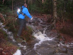 so we got up early and were heading out on the great gulf trail into the hard driving rain just around 6:45am. we started 4 miles north of the amc visitors center at pinkham notch across from camp dodge. the first bridge over the peabody river was massively swollen compared to just 12hrs before when we had looked at it. as we headed up the great gulf trail we crossed many small swollen streams. it was pouring and the warm weather was melting the 78 inches of snow these mountains had gotten a few weeks previous. we found out later the 60 degree temps were a record high for nov 17th. krissy questioned why we had so much gortex on as we stripped our jackets off. i tried to remind her of mount washingtons' notorious weather and it's "highest recorded winds" (see the picture of the sign above!).
from great gulf trail we then headed straight up our 4,100 foot climb to mt madison at 5,367 ft. the osgood trail was basically a river with 3-4 inches of water pouring down on our feet as we tried to keep up our pace. i think my feet were dry for about 3 minutes of this trek. as we started to get closer to the tree line the high winds were frightening and loud. could we spend hours exposed to this kind of wind? i wasn't convinced. the weather said it would die, but weather reporting is not an exact science, so i had my doubts. we stopped to bundled up with winter gloves, hats, and hoods.. then headed up through tree line into the wind.
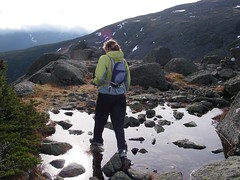
 60-70 mph winds will knock you down. and that is exactly what the gusts did. while hiking we would frequently have to put all fours down to steady ourselves and not fall over. it was a bit crazy and touch and go for a while. the video below of krissy is a good example of how high the winds were. the guidebook estimates said 5hrs to summit mt madison. i figured we'd do it in half the time and we did manage to summit in 2.5hrs. we had agreed we wouldn't decide on whether to continue or not until we hit the saddle between mt madison and mt adams. the presidentials are called the "great rock piles" because that is exactly what they are... granite rock piles. there is no trail to run, cairns guide your way and i could imagine how hard it would be to stay on track with serious winter weather. the skies were basically clear except the clouds surrounding mt washington. we had amazing views of the surrounding terrain. it was spectacular and although we could barely hear each other unless we were inches away with all the wind, we were all smiles as we struggled to hike/walk on the rocks.
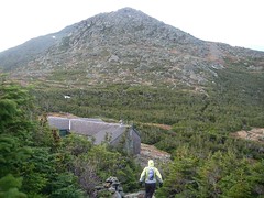
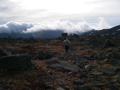
 mt clay was in a cloud, and as we headed down the ridge, then up to mt washington, the highest peak in the northeast at 6,288ft, we traveled deeper into the cloud. as we approached i told krissy that we would soon be crossing the cog's train track up the side of mt washington. just as the cloud cleared, we first saw the tracks, then the cloud kept moving and right in front of us was the weather station and tower.. we were soo close!! it was awesome and our moods instantly changed as the sun hit us. the camera came out, the pace quickened and the smiles were ear to ear.
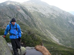
 to that point we hadn't seen a single soul. as we approached the summit the weather station workers had come outside and were watching us from the tower climb the large boulders to the summit. although i'd skied tuckerman's ravine, i had never summited mt washington in my life so that was a great feeling and well overdue. this being the highest mountain in the northeast meant the rest of the trek would generally be downhill, although each summit meant climbing to each peak from the trail.
 in order we hit:
my gear:
shoes: montrail hardrock w/teko ecomerino wool socks & yankz laces
fuel: perpetuem, hammer gel, heed
pack: gregory stimulus w/two nathan handheld
electrolytes: nuun

for these reasons i had been watching the weather since i arrived. it was clear and warm on thurs nov 16th. it would have been the best day to attempt the traverse. however krissy had just arrived late on wed, and asking her to sleep 2-3hrs and get up for a 26 mile, 10,000 foot trek with iffy weather just wouldn't have been fair. although chances are she would have done it. so i proposed going friday. friday's weather was not as good. high winds at 60-75mph and torrential rains were hitting the presidentials thurs night. the mount washington weather site said the rain and wind would start to clear late morning/noon. we expected the traverse to take us anywhere from 8-12hrs. because of the exposure, your speed on this route completely depends on the conditions, and your ability to climb and more importantly descend rocky terrain. my mother and her husband david helped us do our recon thurs and drop a car at crawford notch for our return drive home from the trek - which would take us over 11 summits one way from pinkham to crawford notch.
let's just say i was a bit worried about the weather. i was awaken the night before by the pounding wind and rain. i started to question whether this was a good idea and i couldn't sleep. i decided that we would at the very least climb the first peak, mt madison, and make a decision from there.
from great gulf trail we then headed straight up our 4,100 foot climb to mt madison at 5,367 ft. the osgood trail was basically a river with 3-4 inches of water pouring down on our feet as we tried to keep up our pace. i think my feet were dry for about 3 minutes of this trek. as we started to get closer to the tree line the high winds were frightening and loud. could we spend hours exposed to this kind of wind? i wasn't convinced. the weather said it would die, but weather reporting is not an exact science, so i had my doubts. we stopped to bundled up with winter gloves, hats, and hoods.. then headed up through tree line into the wind.
after 3hrs we were on our way up mt adams (5,774 ft) the second highest peak, mt washington is the highest at 6,288 ft, in the northeast and the highest peak without road access. we actually had some sun on us for a while. from mt adams we then traveled down the ridge to mt jefferson (5,712ft) and mt clay (5,533ft).
- mt madison (5,367ft)
- mt adams (5,774ft - 2nd highest in the northeast)
- mt jefferson (5,712ft)
- mt clay (5,533ft)
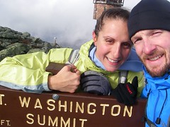
- mt washington (6,288ft - highest peak in the northeast) > lakes of the clouds (the coolest amc hut)
- mt monroe (5,372ft)
- mt franklin (5,001ft)
- mt eisenhower (4,780ft)
- mt pierce (4,310ft)
- mt jackson (4,052ft)
- mt webster (3,910ft)
my gear:
shoes: montrail hardrock w/teko ecomerino wool socks & yankz laces
fuel: perpetuem, hammer gel, heed
pack: gregory stimulus w/two nathan handheld
electrolytes: nuun
 Subscribe to Matt's RSS Feed
